Trip Report: Mount Baker
Corie: When the forecast for Mount Baker rolled around early in the week, Andy and I were psyched. For the first time, we were being presented with a weather window, however small, to climb our first “new to us” mountain since January. We were incredibly psyched. The only caveat was this: we would get to climb Mount Baker in a single push or we would not get to climb it at all.
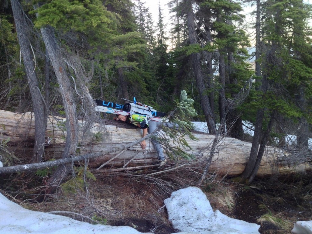
Bright and early on Saturday, we discovered that the Boulder Ridge trail was very overgrown and we soon began encountering monstrous windfalls at increasingly frequent intervals- trees so big that we had to climb around them or belly flop our way over them. To make matters worse, before we reached the end of the ‘maintained’ trail, our path was intermittently interrupted with deep puddles that left Andy’s feet soaked and my feet very damp (thank you, Merrell for using GORE-TEX!).
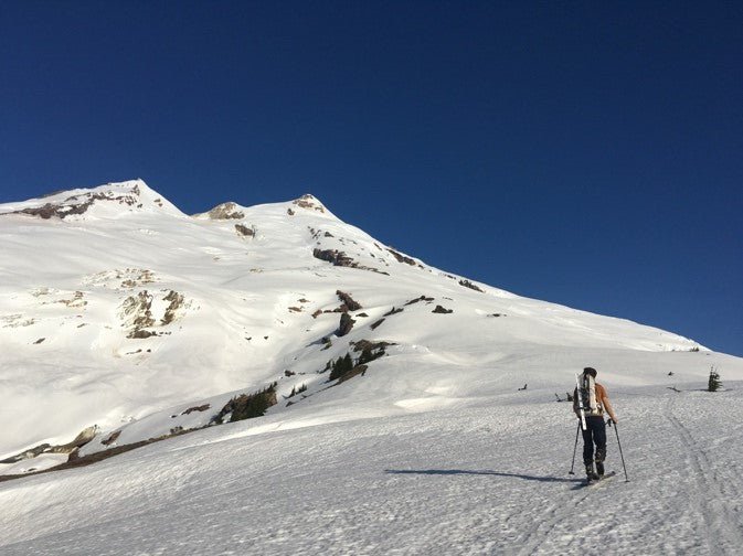
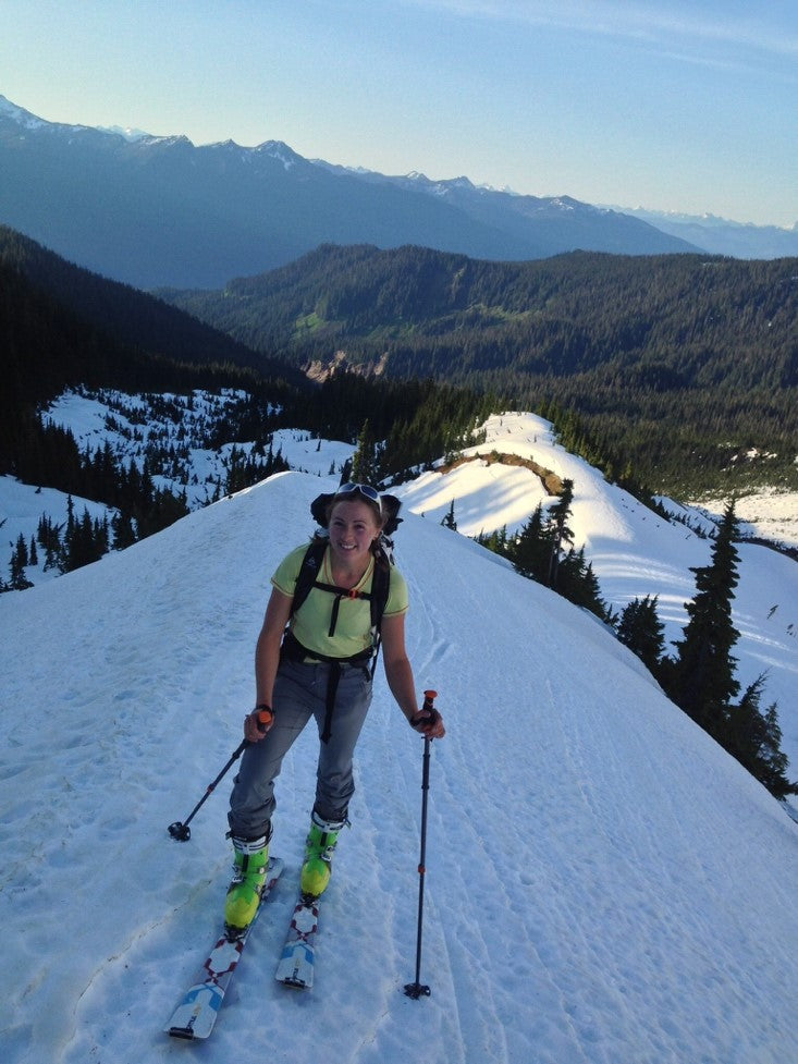
 About 3 miles up the trail, we hit snow and were finally able to ditch our wet shoes and switch to skis and ski boots. At that point, we heard voices behind us and saw a group of 4 guys rolling up- more day-trippers! Still carefully babying my knee/IT band, I moved slowly and I definitely felt like a total gumby when the group of 4 guys caught and passed us, their superior skinning skills making me green with envy. Being such a new skier, I don’t have the amount of confidence it takes to skin straight up steep sections of soft snow.
 Halfway up the cleaver we saw a group of skiers heading down. After a quick conversation we learned that they had bailed after one member of their party had fallen into a crevasse. They had pulled him out without much trouble but had decided to call it a day.
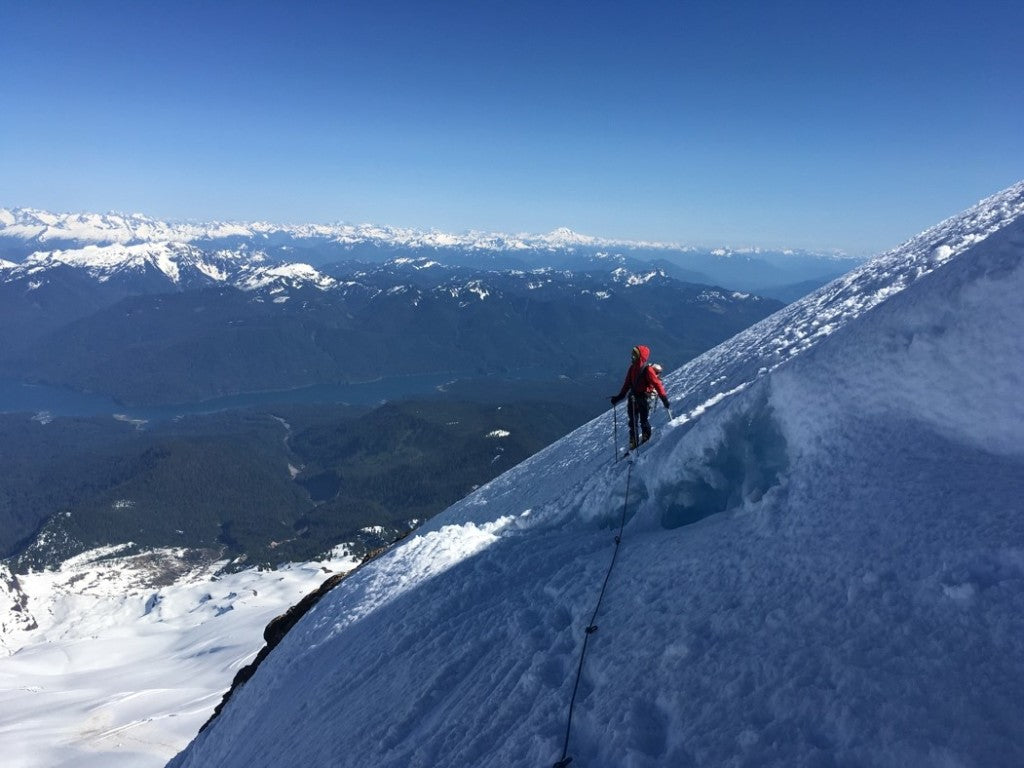
We left our skis at the top of the cleaver since neither of us were psyched at having to ski down through a maze of snow bridges and crevasses. Andy set out to break trail for the first section since I was still wary of how well my knee would handle post-holing. I was reminded that traveling as a rope team takes FOREVER. Navigating the traverses across steeper bits of solid snow, however, was quick and easy and I grew more appreciative than ever of the partnership that Andy and I have.
As the summit grew closer, we switched spots and I led us up to the top. We met the group of skiers at the summit and they did a little good-natured shit talking as they stepped into their bindings for the ski down. “Getting old already, are ya?” one of them chided. I laughed and replied, “I definitely feel old! And I’m wishing I hadn’t forgotten the beer at home!” They laughed at the ridiculousness of my concern and jested that they might leave us a beer at the trailhead- if we were lucky.
Halfway up the cleaver we saw a group of skiers heading down. After a quick conversation we learned that they had bailed after one member of their party had fallen into a crevasse. They had pulled him out without much trouble but had decided to call it a day.
We left our skis at the top of the cleaver since neither of us were psyched at having to ski down through a maze of snow bridges and crevasses. Andy set out to break trail for the first section since I was still wary of how well my knee would handle post-holing. I was reminded that traveling as a rope team takes FOREVER. Navigating the traverses across steeper bits of solid snow, however, was quick and easy and I grew more appreciative than ever of the partnership that Andy and I have.
As the summit grew closer, we switched spots and I led us up to the top. We met the group of skiers at the summit and they did a little good-natured shit talking as they stepped into their bindings for the ski down. “Getting old already, are ya?” one of them chided. I laughed and replied, “I definitely feel old! And I’m wishing I hadn’t forgotten the beer at home!” They laughed at the ridiculousness of my concern and jested that they might leave us a beer at the trailhead- if we were lucky.
 The way down went without incident- quickly plunge-stepping our way through solid snow and carefully tip toeing (and in some cases, jumping) across snow bridges until we made it back to our skis. Our hope at having decent conditions faded quickly as our skis slid out onto packed snow and ice. I packed my skis down a couple hundred feet- post-holing and getting more frozen water inside my ski boots. Eventually, the snow softened and we got into some sweet turns.
 We hustled down to the edge of the snow and quickly switched to hiking shoes as the light faded. We then ran into the reason we got back to the car in the dark- the GPS was dead and all of our tracks had either melted out or been washed away by snow melt. It was time to navigate the old fashioned way.
An hour and a half later, we navigated our way back to the Boulder Ridge trail and began the brutal process of climbing over the same giant trees in the dark. Exhausted, cursing, and covered in bruises from falling, we made it back to the car at 10:30pm- over 18 hours after leaving the trailhead- to find 2 beers waiting for us, courtesy of our skier pals :)
It was a horribly long day and I was pretty worked for a couple of days. However, Baker was such a beautiful mountain that I would be happy to go back for another push. This time, however, I’m bringing waterproof trail shoes and a change of socks.
Andy: We set the alarm for 3:30am and started up the trail 20 minutes later after a quick cup of tea and some oatmeal. As Corie mentioned, we found a generous supply of winter blow-down and large puddles on trail. I’d highly recommend GORE-TEX-fortified trail runners or boots. I wore my non-waterproof trail running shoes and got wet quickly, which made for soggy feet all day. Many descriptions of this route state that after 2 miles, the trail ends in a meadow or bog, depending on the season. I read many stories of epic bushwacks from here to the toe of the glacier. There is a trail on the other side of the bog and although it is not distinct (think ‘climbers trail’ not ‘hiking trail’) it does provide good access through the forest and up to Boulder Ridge. The trail starts directly behind a campsite on the far side of the meadow.
We hustled down to the edge of the snow and quickly switched to hiking shoes as the light faded. We then ran into the reason we got back to the car in the dark- the GPS was dead and all of our tracks had either melted out or been washed away by snow melt. It was time to navigate the old fashioned way.
An hour and a half later, we navigated our way back to the Boulder Ridge trail and began the brutal process of climbing over the same giant trees in the dark. Exhausted, cursing, and covered in bruises from falling, we made it back to the car at 10:30pm- over 18 hours after leaving the trailhead- to find 2 beers waiting for us, courtesy of our skier pals :)
It was a horribly long day and I was pretty worked for a couple of days. However, Baker was such a beautiful mountain that I would be happy to go back for another push. This time, however, I’m bringing waterproof trail shoes and a change of socks.
Andy: We set the alarm for 3:30am and started up the trail 20 minutes later after a quick cup of tea and some oatmeal. As Corie mentioned, we found a generous supply of winter blow-down and large puddles on trail. I’d highly recommend GORE-TEX-fortified trail runners or boots. I wore my non-waterproof trail running shoes and got wet quickly, which made for soggy feet all day. Many descriptions of this route state that after 2 miles, the trail ends in a meadow or bog, depending on the season. I read many stories of epic bushwacks from here to the toe of the glacier. There is a trail on the other side of the bog and although it is not distinct (think ‘climbers trail’ not ‘hiking trail’) it does provide good access through the forest and up to Boulder Ridge. The trail starts directly behind a campsite on the far side of the meadow.
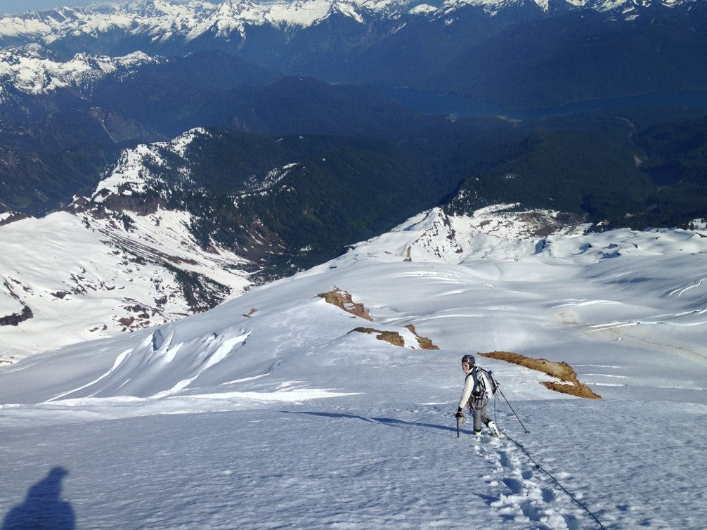
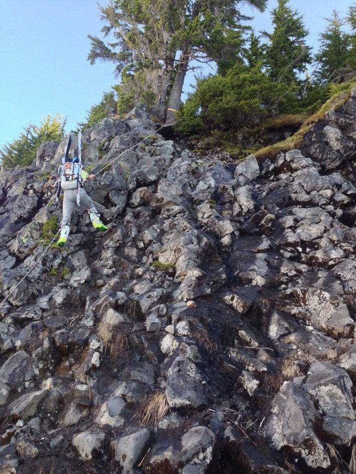 After 3 miles we were able to skin for a while before hitting the 3rd class scramble to gain the ridge. We found the fixed rope, which appeared solid, and used it. Once on top of Boulder Ridge, we began the long skin up the snow slopes. We traded skis for crampons and a rope near the top of the cleaver and carefully picked our way around some of the crevasses on the upper Boulder Glacier.
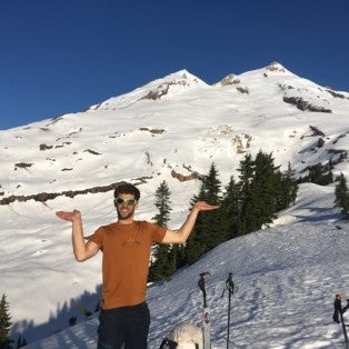
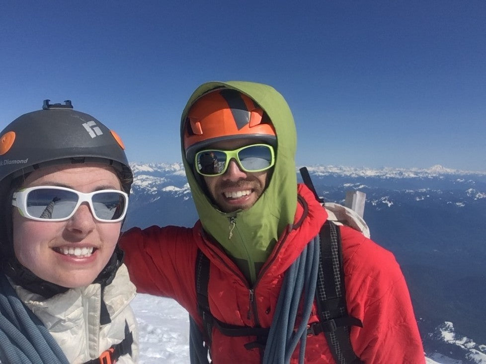
 Most of this route is south-facing and warms quickly, which meant soft snow and we post-holed up to our knees routinely. Many of the snow bridges were still intact and substantial, but soft. We reached the summit around 3:30pm, appalled at our slow progress but relieved. After a few summit selfies we descended to our skis only to find that the upper slopes held a horrid icy crust with wet snow below. The conditions improved greatly as we descended and we managed to get some in some good turns farther down.
 We switched back into our shoes shortly before dark but struggled to find the little trail that led back into the woods. Finding an incredibly faint trail, covered in fallen trees and patches of snow, at dusk, is hard. We knew where we were, but without that little trail, getting out was going to be a major pain. The GPS had died so we broke out the map and compass and headed off into the darkness. A hour or so later, we found the bog and the trail back to the car. After navigating all the downed trees for second time we returned to the car, totally exhausted, but totally stoked.
Equipment List- Boulder Cleaver
- 2 liters of water each
- Lunch/snacks
- Shells/puffys/fleeces
- Skis
- 1st Aid Kit + various other essentials
- Map and GPS
- Sunglasses
- Headlamps
- Ski poles
- Shovel
- Beacons
- Ice axes and crampons
- Crevasse rescue gear
- Hiking shoes for the approach (GORE-TEX recommended)
NOTE: The last 6 miles on forest service gravel roads were potholed, but generally in good condition. Albeit slow, the Corolla made it without incident.
The Stats:
Detailed maps and GPS data can be found on View Ranger
Starting Elevation: 2,723'
Final Elevation: 10,778'
Elevation Gain: 8,328'
Mileage TH to Summit: 6.51
Mileage Roundtrip: ~13
Time TH to Summit: 11 hours 36 mins (not a typo)
Time Roundtrip: 18 hours 30 mins
To learn more about Corie & Andy - the Mountain Refugees Click Here
We switched back into our shoes shortly before dark but struggled to find the little trail that led back into the woods. Finding an incredibly faint trail, covered in fallen trees and patches of snow, at dusk, is hard. We knew where we were, but without that little trail, getting out was going to be a major pain. The GPS had died so we broke out the map and compass and headed off into the darkness. A hour or so later, we found the bog and the trail back to the car. After navigating all the downed trees for second time we returned to the car, totally exhausted, but totally stoked.
Equipment List- Boulder Cleaver
- 2 liters of water each
- Lunch/snacks
- Shells/puffys/fleeces
- Skis
- 1st Aid Kit + various other essentials
- Map and GPS
- Sunglasses
- Headlamps
- Ski poles
- Shovel
- Beacons
- Ice axes and crampons
- Crevasse rescue gear
- Hiking shoes for the approach (GORE-TEX recommended)
NOTE: The last 6 miles on forest service gravel roads were potholed, but generally in good condition. Albeit slow, the Corolla made it without incident.
The Stats:
Detailed maps and GPS data can be found on View Ranger
Starting Elevation: 2,723'
Final Elevation: 10,778'
Elevation Gain: 8,328'
Mileage TH to Summit: 6.51
Mileage Roundtrip: ~13
Time TH to Summit: 11 hours 36 mins (not a typo)
Time Roundtrip: 18 hours 30 mins
To learn more about Corie & Andy - the Mountain Refugees Click Here
About 3 miles up the trail, we hit snow and were finally able to ditch our wet shoes and switch to skis and ski boots. At that point, we heard voices behind us and saw a group of 4 guys rolling up- more day-trippers! Still carefully babying my knee/IT band, I moved slowly and I definitely felt like a total gumby when the group of 4 guys caught and passed us, their superior skinning skills making me green with envy. Being such a new skier, I don’t have the amount of confidence it takes to skin straight up steep sections of soft snow.
Halfway up the cleaver we saw a group of skiers heading down. After a quick conversation we learned that they had bailed after one member of their party had fallen into a crevasse. They had pulled him out without much trouble but had decided to call it a day.
We left our skis at the top of the cleaver since neither of us were psyched at having to ski down through a maze of snow bridges and crevasses. Andy set out to break trail for the first section since I was still wary of how well my knee would handle post-holing. I was reminded that traveling as a rope team takes FOREVER. Navigating the traverses across steeper bits of solid snow, however, was quick and easy and I grew more appreciative than ever of the partnership that Andy and I have.
As the summit grew closer, we switched spots and I led us up to the top. We met the group of skiers at the summit and they did a little good-natured shit talking as they stepped into their bindings for the ski down. “Getting old already, are ya?” one of them chided. I laughed and replied, “I definitely feel old! And I’m wishing I hadn’t forgotten the beer at home!” They laughed at the ridiculousness of my concern and jested that they might leave us a beer at the trailhead- if we were lucky.
The way down went without incident- quickly plunge-stepping our way through solid snow and carefully tip toeing (and in some cases, jumping) across snow bridges until we made it back to our skis. Our hope at having decent conditions faded quickly as our skis slid out onto packed snow and ice. I packed my skis down a couple hundred feet- post-holing and getting more frozen water inside my ski boots. Eventually, the snow softened and we got into some sweet turns.
We hustled down to the edge of the snow and quickly switched to hiking shoes as the light faded. We then ran into the reason we got back to the car in the dark- the GPS was dead and all of our tracks had either melted out or been washed away by snow melt. It was time to navigate the old fashioned way.
An hour and a half later, we navigated our way back to the Boulder Ridge trail and began the brutal process of climbing over the same giant trees in the dark. Exhausted, cursing, and covered in bruises from falling, we made it back to the car at 10:30pm- over 18 hours after leaving the trailhead- to find 2 beers waiting for us, courtesy of our skier pals :)
It was a horribly long day and I was pretty worked for a couple of days. However, Baker was such a beautiful mountain that I would be happy to go back for another push. This time, however, I’m bringing waterproof trail shoes and a change of socks.
Andy: We set the alarm for 3:30am and started up the trail 20 minutes later after a quick cup of tea and some oatmeal. As Corie mentioned, we found a generous supply of winter blow-down and large puddles on trail. I’d highly recommend GORE-TEX-fortified trail runners or boots. I wore my non-waterproof trail running shoes and got wet quickly, which made for soggy feet all day. Many descriptions of this route state that after 2 miles, the trail ends in a meadow or bog, depending on the season. I read many stories of epic bushwacks from here to the toe of the glacier. There is a trail on the other side of the bog and although it is not distinct (think ‘climbers trail’ not ‘hiking trail’) it does provide good access through the forest and up to Boulder Ridge. The trail starts directly behind a campsite on the far side of the meadow.
After 3 miles we were able to skin for a while before hitting the 3rd class scramble to gain the ridge. We found the fixed rope, which appeared solid, and used it. Once on top of Boulder Ridge, we began the long skin up the snow slopes. We traded skis for crampons and a rope near the top of the cleaver and carefully picked our way around some of the crevasses on the upper Boulder Glacier.
Most of this route is south-facing and warms quickly, which meant soft snow and we post-holed up to our knees routinely. Many of the snow bridges were still intact and substantial, but soft. We reached the summit around 3:30pm, appalled at our slow progress but relieved. After a few summit selfies we descended to our skis only to find that the upper slopes held a horrid icy crust with wet snow below. The conditions improved greatly as we descended and we managed to get some in some good turns farther down.
We switched back into our shoes shortly before dark but struggled to find the little trail that led back into the woods. Finding an incredibly faint trail, covered in fallen trees and patches of snow, at dusk, is hard. We knew where we were, but without that little trail, getting out was going to be a major pain. The GPS had died so we broke out the map and compass and headed off into the darkness. A hour or so later, we found the bog and the trail back to the car. After navigating all the downed trees for second time we returned to the car, totally exhausted, but totally stoked.
Equipment List- Boulder Cleaver
- 2 liters of water each
- Lunch/snacks
- Shells/puffys/fleeces
- Skis
- 1st Aid Kit + various other essentials
- Map and GPS
- Sunglasses
- Headlamps
- Ski poles
- Shovel
- Beacons
- Ice axes and crampons
- Crevasse rescue gear
- Hiking shoes for the approach (GORE-TEX recommended)
NOTE: The last 6 miles on forest service gravel roads were potholed, but generally in good condition. Albeit slow, the Corolla made it without incident.
The Stats:
Detailed maps and GPS data can be found on View Ranger
Starting Elevation: 2,723'
Final Elevation: 10,778'
Elevation Gain: 8,328'
Mileage TH to Summit: 6.51
Mileage Roundtrip: ~13
Time TH to Summit: 11 hours 36 mins (not a typo)
Time Roundtrip: 18 hours 30 mins
To learn more about Corie & Andy - the Mountain Refugees Click Here