Trip Report: Backpacking the Loowit Trail on Mount St. Helens
Recommended Duration: 3 Days
Hike Length: 30+ miles, depending on the trailhead
Difficulty: Strenuous
Distance From Portland: 70 miles (1 hr, 30 min)
When to go: Summer (July – early September). Pay attention to snow conditions if hiking early; pay attention to water reports during the end of the summer as water sources can dry up.
Required Passes: NW forest pass (to park at the trailheads)
Hazards: Steep and unstable trail, rock scrambles, stream crossings, snow crossings, sun and weather exposure, water supply
Recommended Experience: Know how to read a map and navigate by GPS or compass; the trail can be difficult to follow in places. Carrying trekking poles and having some experience crossing rivers is recommended. Plan ahead, know how to read the weather, and be prepared for long days of hiking in hot, sunny, and possibly windy conditions.
 Few people realize how close Mt St Helens is to Portland. While driving to Mt Hood to hike or backpack is a common summertime activity, it is just as quick (and far less crowded) to drive to Mt St Helens National Volcanic Monument. Every backpacker in the area has heard of (or hiked) the Timberline Trail- the 40-mile loop around the base of Mt Hood- but few realize that there is a loop around the base of Mt St Helens too: the Loowit Trail. Having done both, I far prefer the slightly shorter (but much more strenuous) Loowit Trail around St Helens for its relative quiet, its remote setting, and its varied and rugged terrain.
The Loowit Trail circumnavigates Mt St Helens mostly above tree line, between the summit of the mountain and the surrounding foothills. It undulates between 3,200 and 4,800 feet in elevation. Because Mt St Helens last erupted in 1980, hiking the Loowit trail is unlike any other backpacking trip in the country. While walking, you will often feel rocks and gravel shift and slide under your feet. Because the last eruption was so recent, the terrain is still eroding and settling into a more stable permanent landscape. On the flanks of St Helens, you can watch river valleys actively erode, cross pumice plains, and scramble over recently deposited lava flows. Unless you are prepared to climb to the summit, there is no better way to get up close and personal with Mt St Helens and to view her many faces of volcanic activity than to hike the Loowit Trail.
 Before You Go
Though there is no permit required to hike or camp on the Loowit Trail (aside from the Northwest Forest Parking Pass), attempting this trip will require some planning. Unlike the Timberline Trail, there is no direct road access to the Loowit Trail. Accessing the trail requires hiking in from one of a few trailheads. You will need to consult a map to plan your trip, but some possible starting points are the Climbers Trailhead, the June Lake Trailhead, and Windy Ridge Trailhead.
I hiked this loop in August of 2021, beginning from the June Lake Trailhead and hiking clockwise around the mountain. Landmarks, features, and mileages in this guide will be given from this starting point; however, it is possible to hike the loop counterclockwise instead. There is a 9.6 mile long no-camping zone along the loop, so your direction of travel will depend on your chosen trailhead and where you plan to camp. (There are no designated campsites along the Loowit Trail, but there are some recommended spots –I'll mention them in the trail description down below.) While most people complete the Loowit trail in 3 days, it can be done in more or less—some people run the loop in a single day, while others stretch the trip to 5 days, allowing for side trips and time to explore along the way. Think about your target daily mileage, the location of campsites along the trail, and where you’ll be able to collect water, and adjust your itinerary as necessary!

Day 1: June Lake Trailhead to Crescent Ridge (11.3 miles)
From the June Lake Trailhead, it is an easy gradual uphill 1.3 miles to the shores of June Lake, a tiny pond nestled in a ravine below the Worm Flows Lava Flows. Hiking to this lake is a worthwhile day trip on its own. You’ll pass by a few campsites as you near the lake if you want to stay the night—if not, continue ahead to the north, following signs for the Loowit Trail. The trail climbs 300 feet in .3 miles. Here you’ll get a first taste for the rugged nature of the hike. Watch out for snags and cave-ins along the trail!
Heading counterclockwise (left) at the top of the June Lake Trail, you’ll skirt the base of the Worm Flows, passing in and out of the forest and steadily climbing. Be sure to look up to the right to check out the lava flows! 1.2 miles later you’ll reach Swift Creek, one of very few water sources on the south side of St Helens. The trail crosses the creek right above Chocolate Falls, but in late summer or even early fall this water source shouldn’t be relied on. We hiked through here in late afternoon during the hottest part of the day, thinking that the heat would cause the Swift Glacier (which supplies the creek water) to melt faster. Even then, the creek was merely a trickle.

On the other side of Chocolate Falls, cross the Worm Flows climbing route (if you look to the right, you can see the route people take up the mountain in the winter) and continue 2 miles uphill toward Monitor Ridge. This section of trail winds through forests, wildflowers, and grassland. Enjoy the shade here while you can, as this is one of the only sheltered sections of the Loowit Trail! At the top of the climb, you’ll cross Monitor Ridge (the summer climbing route). From here the trail gets more exciting, striking out into the lava rock that covers the southeast side of the mountain. Be careful to watch for marker poles and take your time navigating the rocks; there’s no tread, and it’s easy to lose the trail through here!

2 miles beyond Monitor Ridge, you’ll pass the Butte Camp Trail (there is a campsite 1.4 miles to the left here if you need it). 2 miles on, the real fun begins. There are a couple places on the Loowit Trail where volcanic deposits are actively eroding fast enough that there is no stable trail, and you need to use ropes (anchored in place by the forest service) to assist in climbing up and down steep gravel riverbanks; the first of these places is 7.8 miles into the Loowit Trail beyond June Lake Falls. We navigated this section by tossing our hiking poles into the valley and then climbing backwards very slowly down to the riverbed.

About a mile after scrambling across the canyon, the Canyon Trail branches off to the left. Continue straight toward Crescent Ridge. About a mile further through a forest, you’ll start to see camping spots along the right of the trail. This is where we spent our first night. If you camp here, be sure to bring enough water to cook with, as there is none available on Crescent Ridge!

Day 2: Crescent Ridge to the Plains of Abraham (13.2 miles)
Day two crosses the restricted camping area and, as such, is a long day by necessity. Begin the day with a long descent down Crescent Ridge to the Toutle River; at 3200 feet, this is the low point of the Loowit trail (it is also the biggest river ford of the trip, so it’s best to plan to cross early in the day!). Once you’ve crossed the Toutle River, you will be crossing the restricted no-camping zone for the next 9.7 miles. Gather water here, then continue 800 feet uphill over the next 1.4 miles to the top of Castle Ridge and the Castle Ridge Trail.
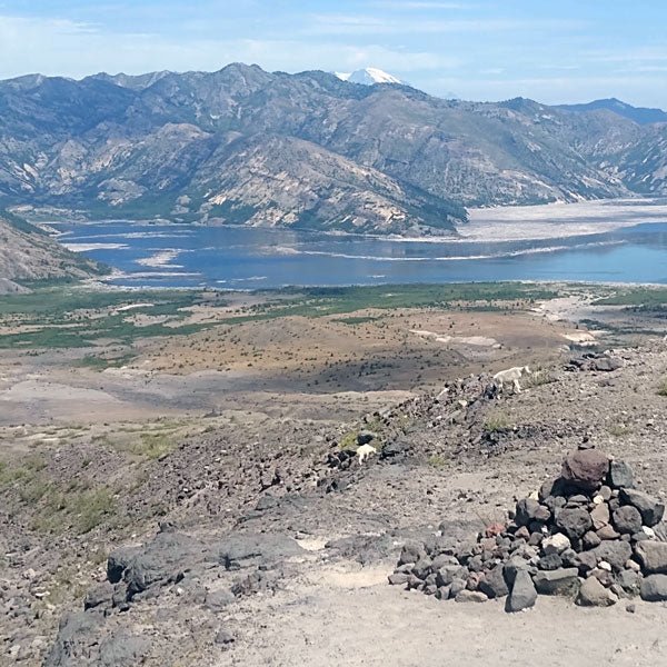
The next 10 miles are the most exposed of the entire Loowit Trail. You will be crossing the Pumice Plain to the north of St Helens, the area directly below the most recent volcanic blast. This is a beautiful and unique geologic area and the trail here is mostly flat, but because of the constantly changing landscape there is no protection for sun or weather until you’ve crossed the plain, so be sure you have plenty of water!

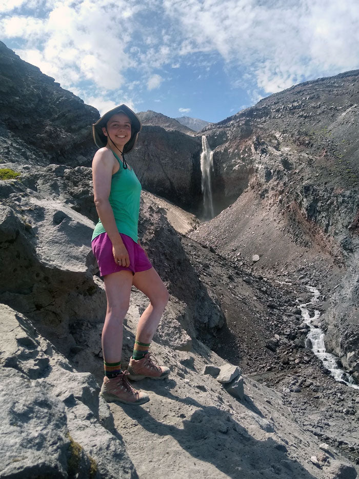
5.4 miles past Castle Ridge you’ll reach the Willow Springs trail; take a right and climb gradually toward Loowit Falls. Though the falls aren’t on the Loowit Trail, a half-mile spur leads to a great viewpoint, and if you have time this is a great addition to the hike!
About half a mile past the Loowit Falls Trail, you’ll reach a beautiful, out-of-place spring—an oasis of green in a landscape of dry rock. Water rushes out of the side of the mountain; be sure to fill up your bottles here, as this is the best water on the entire Loowit Trail! Then continue to the right at the next intersection and climb 500 feet over 1 mile to the top of Windy Pass, the Loowit Trail high point and the end of the restricted camping zone.

From Windy Pass you’ll get your first view of the Plains of Abraham, another flat pumice plain perched high above the valley floor. Descend from Windy Pass and enjoy the last couple miles of easy walking. About 2 miles beyond Windy Pass you’ll see a small patch of trees and a small stream that flows over a cliff at the edge of the Plains of Abraham. This is the first good spot for camping beyond Windy Pass, and one of the nicest camp spots I’ve ever seen—flat ground, great views, wind protection, and flowing water. Enjoy!
Day 3: Plains of Abraham to June Lake (7.2 miles)
From the Plains of Abraham, it is a relatively easy hike back to the starting point. After crossing Ape Canyon Creek (possibly the last water source of the hike) take a right and continue across one last undulating lava field. Though the trail is easier to follow here than it was on the first day of the hike, the footing is still uneven—so move slowly, and watch your step! The most exciting part of this stretch of trail is crossing Shoestring Creek at the base of Shoestring Glacier. Even near the end of the summer, we had to cross a snow-filled canyon; we didn’t use micro spikes, but the footing was a little slippery!

At the next intersection, take a left and descend the trail back down to June Lake, where you can enjoy the falls one last time before returning to your car. Happy Trails!